> > India >> States >> Districts in India
do you want to know How many districts in Himachal Pradesh / Total district in Himachal Pradesh ?
Largest and smallest District in Himachal Pradesh
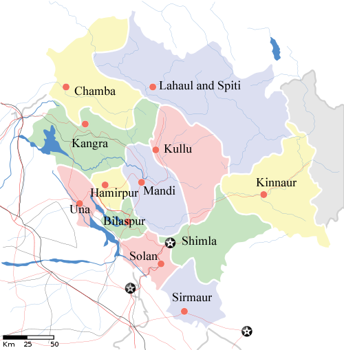
Nestled in the picturesque landscapes of northern India, Himachal Pradesh stands as a serene and enchanting state, renowned for its snow-capped mountains, lush valleys, and vibrant cultural heritage. As of the latest available information in 2024, Himachal Pradesh is administratively organized into 12 districts, each contributing to the state’s governance, economic pursuits, and the preservation of its natural beauty.
Lahaul and Spiti is the largest district in Himachal Pradesh, and Hamirpur District is the smallest district in Himachal Pradesh. Kangra District is the most populated district and Lahaul and Spiti District is the least populated district in Himachal Pradesh.
read about the Population of Himachal Pradesh
| # | District | Population (2011) | Area (km²) |
| 1 | Bilaspur | 3,82,056 | 1,167 |
| 2 | Chamba | 5,18,844 | 6,528 |
| 3 | Hamirpur | 4,54,293 | 1,118 |
| 4 | Kangra | 15,07,223 | 5,739 |
| 5 | Kinnaur | 84,298 | 6,401 |
| 6 | Kullu | 4,37,474 | 5,503 |
| 7 | Lahaul and Spiti | 31,528 | 13,835 |
| 8 | Mandi | 9,99,518 | 3,950 |
| 9 | Shimla | 8,13,384 | 5,131 |
| 10 | Sirmaur | 5,30,164 | 2,825 |
| 11 | Solan | 5,76,670 | 1,936 |
| 12 | Una | 5,21,057 | 1,540 |
read about religion in Himachal Pradesh
Himachal Pradesh District Map

Largest and Smallest District in Himachal Pradesh by Area
Lahaul and Spiti district covering an area of 13835 km² is the largest district in Himachal Pradesh, Hamirpur District is the smallest district in Himachal Pradesh of with a total area of 1118 km²
| # By Area | District | Area |
| Largest | Lahaul & Spiti | 13835 km² |
| Smallest | Hamirpur | 1118 km2 |
Source: Census 2011
Largest and Smallest District in Himachal Pradesh by Population
Kangra District is the most populated district in Himachal Pradesh. Its Population as per the census 2011 is 15 Lakhs Lakhs. Lahaul and Spiti District with a population of 31,528 is the least populated district in
| # by Population | District | Population (Census 2011) |
| Most Populated | Kangra | 1,507,223 |
| Least | Lahaul & Spiti | 31,528 |
Highest and Lowest Population Density
Hamirpur District (406 people per km) has the highest Population density in Himachal Pradesh. Lahaul and Spiti District with a population density of 2 people per km is the lowest-density district in Himachal Pradesh.
| # by Density | District | Density (person/km) |
| Highest | Hamirpur | 406 |
| Least | Lahaul & Spiti | 2 |
Source: Census 2011
Himachal Pradesh Districts by Literacy Rate | Sex Ratio | Density
| # | District | Density | Sex Ratio | Literacy rate |
| 1 | Bilaspur | 327 | 981 | 84.59% |
| 2 | Chamba | 80 | 986 | 72.17% |
| 3 | Hamirpur | 406 | 1095 | 88.15% |
| 4 | Kangra | 263 | 1012 | 85.67% |
| 5 | Kinnaur | 13 | 819 | 80.00% |
| 6 | Kullu | 79 | 942 | 79.40% |
| 7 | Lahaul and Spiti | 2 | 903 | 76.81% |
| 8 | Mandi | 253 | 1007 | 81.53% |
| 9 | Shimla | 159 | 915 | 83.64% |
| 10 | Sirmaur | 188 | 918 | 78.80% |
| 11 | Solan | 298 | 880 | 83.68% |
| 12 | Una | 328 | 976 | 86.53% |
Source: Census 2011
Himachal Pradesh District with Highest and Lowest Literacy rate
| # by Literacy Rate | District | Literacy Rate |
| Most Literate | Hamirpur | 88.15% |
| Least | Chamba | 72.17% |
Source: Census 2011
Himachal Pradesh Districts with Highest and Lowest Sex Ratio
Hamirpur district (1095) has the highest Male-Female Sex ratio in Himachal Pradesh. Kinnaur District (819) has the lowest male-female sex ratio in Himachal Pradesh.
| # by Literacy Rate | District | Sex ratio (females to 1000 males) |
| Highest | Hamirpur | 1095 |
| Lowest | Kinnaur | 819 |
Source: Census 2011
Know more about Himachal Pradesh
