> > India >> States >> Districts in India
Largest and Smallest District in Bihar
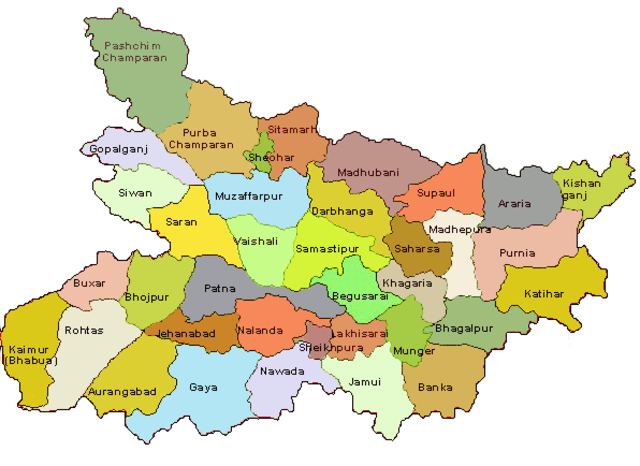
Situated in the eastern part of India, Bihar holds a distinct position as one of the most populous states in the country, following Uttar Pradesh and Maharashtra. With an expansive area of 94,163 square kilometers, Bihar is the 12th largest state in terms of landmass. As of the latest available information in 2024, Bihar is administratively divided into 38 districts, each contributing to the state’s rich historical, cultural, and economic landscape. These districts, in turn, are meticulously organized into 101 subdivisions, forming a hierarchical administrative structure.
Patna District is the most populated District and Sheikhpura District is the least populated district in Bihar. West Champaran district is the largest district by area and Sheohar District is the smallest district of Bihar.
read about the Population of Bihar
| # | District | Population (2011) | Area (km²) |
| 1 | Araria | 2,806,200 | 2,829 |
| 2 | Arwal | 700,843 | 638 |
| 3 | Aurangabad | 2,511,243 | 3,303 |
| 4 | Banka | 2,029,339 | 3,018 |
| 5 | Begusarai | 2,954,367 | 1,917 |
| 6 | Bhagalpur | 3,032,226 | 2,569 |
| 7 | Bhojpur | 2,720,155 | 2,473 |
| 8 | Buxar | 1,707,643 | 1,624 |
| 9 | Darbhanga | 3,921,971 | 2,278 |
| 10 | East Champaran | 5,082,868 | 3,969 |
| 11 | Gaya | 4,379,383 | 4,978 |
| 12 | Gopalganj | 2,558,037 | 2,033 |
| 13 | Jamui | 1,756,078 | 3,099 |
| 14 | Jehanabad | 1,124,176 | 1,569 |
| 15 | Kaimur | 1,626,900 | 3,363 |
| 16 | Katihar | 3,068,149 | 3,056 |
| 17 | Khagaria | 1,657,599 | 1,486 |
| 18 | Kishanganj | 1,690,948 | 1,884 |
| 19 | Lakhisarai | 1,000,717 | 1,229 |
| 20 | Madhepura | 1,994,618 | 1,787 |
| 21 | Madhubani | 4,476,044 | 3,501 |
| 22 | Munger | 1,359,054 | 1,419 |
| 23 | Muzaffarpur | 4,778,610 | 3,173 |
| 24 | Nalanda | 2,872,523 | 2,354 |
| 25 | Nawada | 2,216,653 | 2,492 |
| 26 | Patna | 5,772,804 | 3,202 |
| 27 | Purnia | 3,273,127 | 3,228 |
| 28 | Rohtas | 2,962,593 | 3,850 |
| 29 | Saharsa | 1,897,102 | 1,702 |
| 30 | Samastipur | 4,254,782 | 2,905 |
| 31 | Saran | 3,943,098 | 2,641 |
| 32 | Sheikhpura | 634,927 | 689 |
| 33 | Sheohar | 656,916 | 443 |
| 34 | Sitamarhi | 3,419,622 | 2,199 |
| 35 | Siwan | 3,318,176 | 2,219 |
| 36 | Supaul | 2,228,397 | 2,410 |
| 37 | Vaishali | 3,495,021 | 2,036 |
| 38 | West Champaran | 3,935,042 | 5,229 |
read about religion in Bihar
Bihar District Map

Largest and Smallest District in Bihar by Area
West Champaran district covering an area of 5229 km² is the largest district of Bihar. Sheohar District is the smallest district of Bihar with a total area is 443 km²
| # By Area | District | Area |
| Largest | West Champaran | 5229 km² |
| Smallest | Sheohar | 443 km2 |
Source: Census 2011
Largest and Smallest District in Bihar by Population
Patna District is the most populated district in Uttar Pradesh. Its Population as per census 2011 is 57.80 Lakhs. Sheikhpura District with a population of 6.35 lakhs is the least populated district in Bihar.
| # by Population | District | Population (Census 2011) |
| Most Populated | Patna | 5772804 |
| Least | Sheikhpura | 634927 |
Highest and Lowest Population Density
Sheohar District (1882 people per km) has the highest Population density in Bihar. Kaimur District with a population density of 488 people per km is the lowest-density district in Bihar.
| # by Density | District | Density (person/km) |
| Highest | Sheohar | 1882 |
| Least | Kaimur | 488 |
Source: Census 2011
Bihar District with Highest and Lowest Literacy rate
| # by Literacy Rate | District | Literacy Rate |
| Most Literate | Rohtas | 73.37% |
| Least | Purnia | 51.08% |
Source: Census 2011
Bihar District with Highest and Lowest Sex Ratio
Gopalganj district (1021) has the highest Male-Female Sex ratio in Bihar. Munger District (876) has the lowest male-female sex ratio in Bihar
| # by Literacy Rate | District | Sex ratio |
| Highest | Gopalganj | 1021 females to 1000 males |
| Lowest | Munger | 876 females to 1000 males |
Source: Census 2011
Know more about Bihar
